Timeline story
Mantle Rock and the Trail of Tears, 1838–39
West of the crossroads of Joy in Livingston County, off KY 133, a sandstone arch about 30 feet high and 188 feet long stands in the woods of the McGilligan Creek watershed, one of the longest natural arches in Kentucky.
Nearby runs a stretch of the old Salem–Golconda Road, and in the winter of 1838–39 that road carried the Cherokee Nation’s forced removal on the northern route of the Trail of Tears. Eleven detachments, more than 10,000 Cherokee in all, came this way toward Berry’s Ferry on the Ohio and the crossing to Golconda, Illinois, not yet halfway to Indian Territory.
Ice closed the river that winter. The Peter Hildebrand detachment, about 1,766 people, spent roughly two bitterly cold weeks in camps strung for miles along the road, waiting for the river to thaw enough for the ferry. A state historical marker says the Cherokee sheltered beneath the arch and that many died there; the National Park Service says there were far too many people to camp under it, that historical descriptions point to a long camp along the road, and that there is no evidence of burials at Mantle Rock.
Across the river, many were trapped again between the frozen Ohio and Mississippi, and the detachments reached Oklahoma hundreds fewer than they started. The Nature Conservancy owns the 367-acre preserve. It was listed on the National Register in 2004 as the Mantle Rock Archeological District and certified that year as a site on the Trail of Tears National Historic Trail, and a 2.75-mile loop trail follows about a mile of the old road.
The map pin marks the Kentucky Historical Society’s Mantle Rock marker (#1675) on KY 133.
View the map
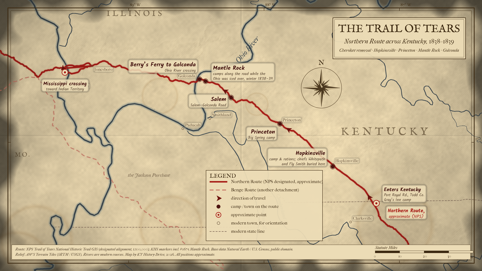
On the Northern Route of the Trail of Tears, Cherokee detachments entered Kentucky on the Port Royal Road in Todd County, camped at Hopkinsville and Princeton, followed the Salem–Golconda Road through Salem past Mantle Rock, and crossed the Ohio at Berry's Ferry to Golconda, Illinois, before heading west to the Mississippi.
About 120 miles across Kentucky from the Tennessee line to Berry's Ferry, plus about 130 more across southern Illinois to the Mississippi crossing, measured on the map line.
Opens a larger view of this map.
Solid: Northern Route (NPS designated, approximate) · Light dashes: Benge Route (another detachment). Map: Kentucky History Drive.
Solid: Northern Route (NPS designated, approximate). Map: Kentucky History Drive.
Kentucky leg shown — view full route
Download GPX (approximate) Download KML (approximate) for GPS and map apps
Approximate stops, in order of travel
- near Guthrie, Todd County, Kentucky (enters Kentucky on the Port Royal Road)
- Hopkinsville, Christian County, Kentucky (Hopkinsville camp)
- Princeton, Caldwell County, Kentucky (Big Spring camp)
- Salem, Livingston County, Kentucky (Salem)
- near Joy, Livingston County, Kentucky (Mantle Rock)
- opposite Golconda, Livingston County, Kentucky, and Pope County, Illinois (Berry's Ferry)
- near Cape Girardeau, Missouri, Union and Alexander counties, Illinois, and Cape Girardeau County, Missouri (Mississippi crossing)
Sources: NPS Trail of Tears National Historic Trail GIS; KHS marker #1675.
Cite this story
Published . Last revised .
Chicago
Snowden, Shannon. "Mantle Rock and the Trail of Tears, 1838–39." Kentucky History Drive. Published October 9, 2026. Last revised October 9, 2026. https://kyhistorydrive.com/stories/mantle-rock-and-the-trail-of-tears/.
MLA
Snowden, Shannon. "Mantle Rock and the Trail of Tears, 1838–39." Kentucky History Drive, published 9 Oct. 2026, last revised 9 Oct. 2026, https://kyhistorydrive.com/stories/mantle-rock-and-the-trail-of-tears/.
Report a correction for Mantle Rock and the Trail of Tears, 1838–39 (opens in a new tab)