Timeline story
William Calk’s 1775 journal
From March 13 to May 2, 1775, William Calk kept a plainspoken daybook of his trek from Prince William County, Virginia, to Boone’s Fort on the Kentucky River.
The manuscript—held by the Kentucky Historical Society—records mud, cold, lost livestock, meetings with Henderson’s Transylvania party, and the scramble to claim land. Calk later settled near Hinkston Creek and Mount Sterling; his diary remains one of the clearest settler voices from the first season of organized immigration.
View the map
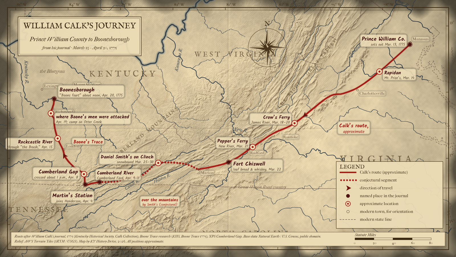
William Calk walked from Prince William County, Virginia, by Rapidan and over the Blue Ridge, down the Valley to Crow's Ferry, Pepper's Ferry on the New River and Fort Chiswell, across the Clinch country to Martin's Station in Powell Valley, through Cumberland Gap on April 8, and along Boone's Trace by the Cumberland, Laurel and Rockcastle rivers to Boonesborough on April 20, 1775.
About 490 miles, a 39-day trip including a five-day snowbound stop on the Clinch, measured on the map line.
Opens a larger view of this map.
Solid: Calk's route (approximate) · Dotted: conjectural segment. Map: Kentucky History Drive.
Solid: Calk's route (approximate). Map: Kentucky History Drive.
Hexagon: conjectural stop
Kentucky leg shown — view full route
Download GPX (approximate) Download KML (approximate) for GPS and map apps
Approximate stops, in order of travel
- Manassas area, Prince William County, Virginia (sets out from Prince William)
- Rapidan, Culpeper and Orange counties, Virginia (Mr. Prize's)
- Charlottesville area, Albemarle County, Virginia (Mr. Car's on the North Fork of the James)
- Crozet / Staunton area, Albemarle and Augusta counties, Virginia (Mr. Black's and James Loyl's)
- Buchanan area, Botetourt County, Virginia (William Anderson's at Crow's Ferry)
- Catawba valley, Roanoke and Botetourt counties, Virginia (Wm. Adams's)
- near Radford, Montgomery and Pulaski counties, Virginia (Pepper's Ferry)
- Fort Chiswell, Wythe County, Virginia (Fort Chiswell)
- Royal Oak / Marion, Smyth County, Virginia (Major Campbell's on the Holston)
- north of Saltville, Smyth and Washington counties, Virginia (Laurel Fork of the Holston, conjectural)
- Castlewood, Russell County, Virginia (Daniel Smith's on the Clinch, conjectural)
- Dungannon area, Scott County, Virginia (Briley's mill, conjectural)
- Duffield and Powell Valley, Scott and Lee counties, Virginia (Clinch River, Cove Creek, and Powell Mountain, conjectural)
- Martin's Station, Wilderness Road State Park, Ewing, Lee County, Virginia (Capt. Martin's)
- near Ewing, Lee County, Virginia (Indian Creek camp)
- Cumberland Gap, Bell County, Kentucky, Lee County, Virginia, and Claiborne County, Tennessee (Cumberland Gap)
- Pineville, Bell County, Kentucky (Cumberland River (Cumberland Ford))
- Barbourville area, Knox County, Kentucky (Richland Creek)
- near Corbin / London, Laurel County, Kentucky (Laurel River)
- near Livingston / Hazel Patch, Rockcastle and Laurel counties, Kentucky (Rockcastle River)
- Berea area, Rockcastle and Madison counties, Kentucky (Roundstone Creek and the Blue Lick)
- south of Richmond, Madison County, Kentucky (Twetty's Fort site and Otter Creek)
- Fort Boonesborough State Park, Madison County, Kentucky (Boonesborough)
Sources: Calk journal (KHS); Boone Trace research; NPS Cumberland Gap.
Cite this story
Published . Last revised .
Chicago
Snowden, Shannon. "William Calk’s 1775 journal." Kentucky History Drive. Published September 24, 2026. Last revised September 24, 2026. https://kyhistorydrive.com/stories/william-calks-1775-journal/.
MLA
Snowden, Shannon. "William Calk’s 1775 journal." Kentucky History Drive, published 24 Sept. 2026, last revised 24 Sept. 2026, https://kyhistorydrive.com/stories/william-calks-1775-journal/.
Report a correction for William Calk’s 1775 journal (opens in a new tab)