Timeline story
Athiamiowee: the Warriors’ Path through Kentucky
Long before the Wilderness Road, the main north–south route through eastern Kentucky was a Native trail the Shawnee called Athiamiowee, the “Path of the Armed Ones.” It linked the Shawnee and other nations north of the Ohio with the Cherokee towns of east Tennessee and the southern Appalachians.
Like most Native routes it followed old game trails worn by elk and buffalo through gaps and valleys, and it was marked or blazed along the way.
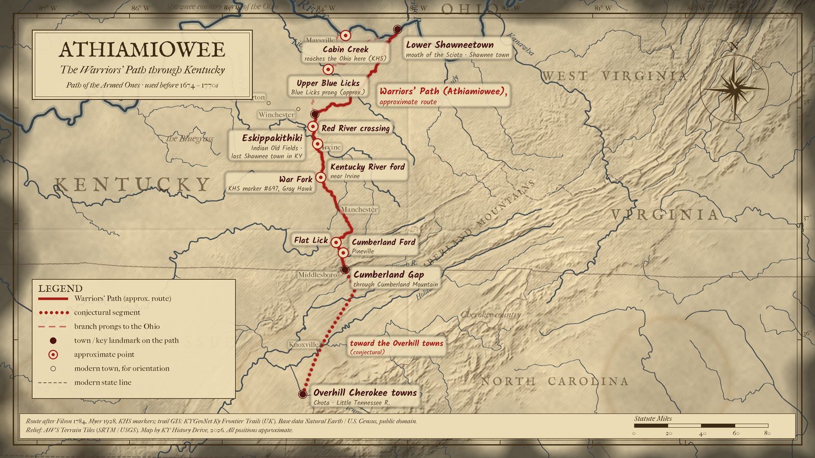
The Shawnee and Cherokee, often bitter enemies, both used it to reach the Kentucky hunting grounds and to raid each other, and English speakers were calling it the Warriors’ Path by the 1750s. In Kentucky it came north through Cumberland Gap, crossed the Cumberland River at Cumberland Ford (present Pineville), followed the river toward Flat Lick, then ran overland to Goose Creek in Clay County and along War Fork in Jackson County. It crossed Powell County and part of Clark County near the Shawnee town of Eskippakithiki, crossed the Licking River near Blue Licks, and reached the Ohio at Cabin Creek in Mason County.

Gabriel Arthur followed it in 1674 after his Native captors released him, and Thomas Walker in 1750, Christopher Gist in 1751, and John Finley with Daniel Boone in 1769 all used it; John Filson’s 1784 map of Kentucky shows it. A Kentucky Historical Society marker (#697) on US 421 at Gray Hawk notes that the path ran along War Fork two miles east, and the map pin marks that marker.
View the map
The Warriors' Path ran from the Ohio River opposite the mouth of the Scioto (Lower Shawneetown, near present South Portsmouth) south past Eskippakithiki in Clark County, across the Red and Kentucky rivers near Irvine, along War Fork and Goose Creek to Flat Lick, over the Cumberland River at Pineville, and through Cumberland Gap toward the Cherokee Overhill towns on the Little Tennessee River.
About 220 miles from the Ohio to Cumberland Gap, plus roughly 80–90 more (conjectural) to the Overhill towns, measured on the map line.
Opens a larger view of this map.
Solid: Warriors' Path (approximate) · Dotted: conjectural segment · Light dashes: branch prongs to the Ohio. Map: Kentucky History Drive.
Solid: Warriors' Path (approximate). Map: Kentucky History Drive.
Hexagon: conjectural stop
Kentucky leg shown — view full route
Download GPX (approximate) Download KML (approximate) for GPS and map apps
Approximate stops, north to south
- South Portsmouth / Fullerton, Greenup County, Kentucky, and Scioto County, Ohio (Lower Shawneetown)
- near Olive Hill and the Mount Sterling area, Carter, Bath, and Montgomery counties, Kentucky (Scioto prong, conjectural)
- Indian Fields, Clark County, Kentucky (Eskippakithiki)
- near Clay City, Clark, Powell, and Estill counties, Kentucky (Red River crossing)
- Irvine, Estill County, Kentucky (Kentucky River ford)
- Gray Hawk, Jackson County, Kentucky (War Fork / Sand Gap)
- Manchester, Clay County, Kentucky (Goose Creek)
- Flat Lick, Knox County, Kentucky (Flat Lick)
- Pineville, Bell County, Kentucky (Cumberland Ford)
- Middlesboro, Kentucky, and Cumberland Gap, Tennessee (Bell County, Kentucky; Claiborne County, Tennessee; Lee County, Virginia) (Cumberland Gap)
- near Vonore, Monroe County, Tennessee (Overhill Cherokee towns (Chota), conjectural)
A dashed branch runs from Eskippakithiki northeast across the Licking near Upper Blue Licks (Fleming and Nicholas counties) to the Ohio at Cabin Creek (Mason and Lewis counties), with a Maysville prong.
Sources: Filson 1784; KHS marker #697; KYGeoNet Ky Frontier Trails; NPS.
Cite this story
Published . Last revised .
Chicago
Snowden, Shannon. "Athiamiowee: the Warriors’ Path through Kentucky." Kentucky History Drive. Published October 8, 2026. Last revised October 8, 2026. https://kyhistorydrive.com/stories/athiamiowee-the-warriors-path-through-kentucky/.
MLA
Snowden, Shannon. "Athiamiowee: the Warriors’ Path through Kentucky." Kentucky History Drive, published 8 Oct. 2026, last revised 8 Oct. 2026, https://kyhistorydrive.com/stories/athiamiowee-the-warriors-path-through-kentucky/.
Report a correction for Athiamiowee: the Warriors’ Path through Kentucky (opens in a new tab)