Timeline story
Thomas Walker and Cumberland Gap
In March 1750 Dr. Thomas Walker led a Loyal Land Company party through the Appalachians and on April 13 recorded Cave Gap: a plain Indian road, a spring pouring from a cave, marked trees, and a pass visible for miles.
He named the gap and nearby river for the Duke of Cumberland, noted coal on Flat Creek, and later had a small cabin raised near present Barbourville—the first Euro-American house claimed in Kentucky. Walker’s journal mapped the geologic doorway later generations would pour through.
View the map
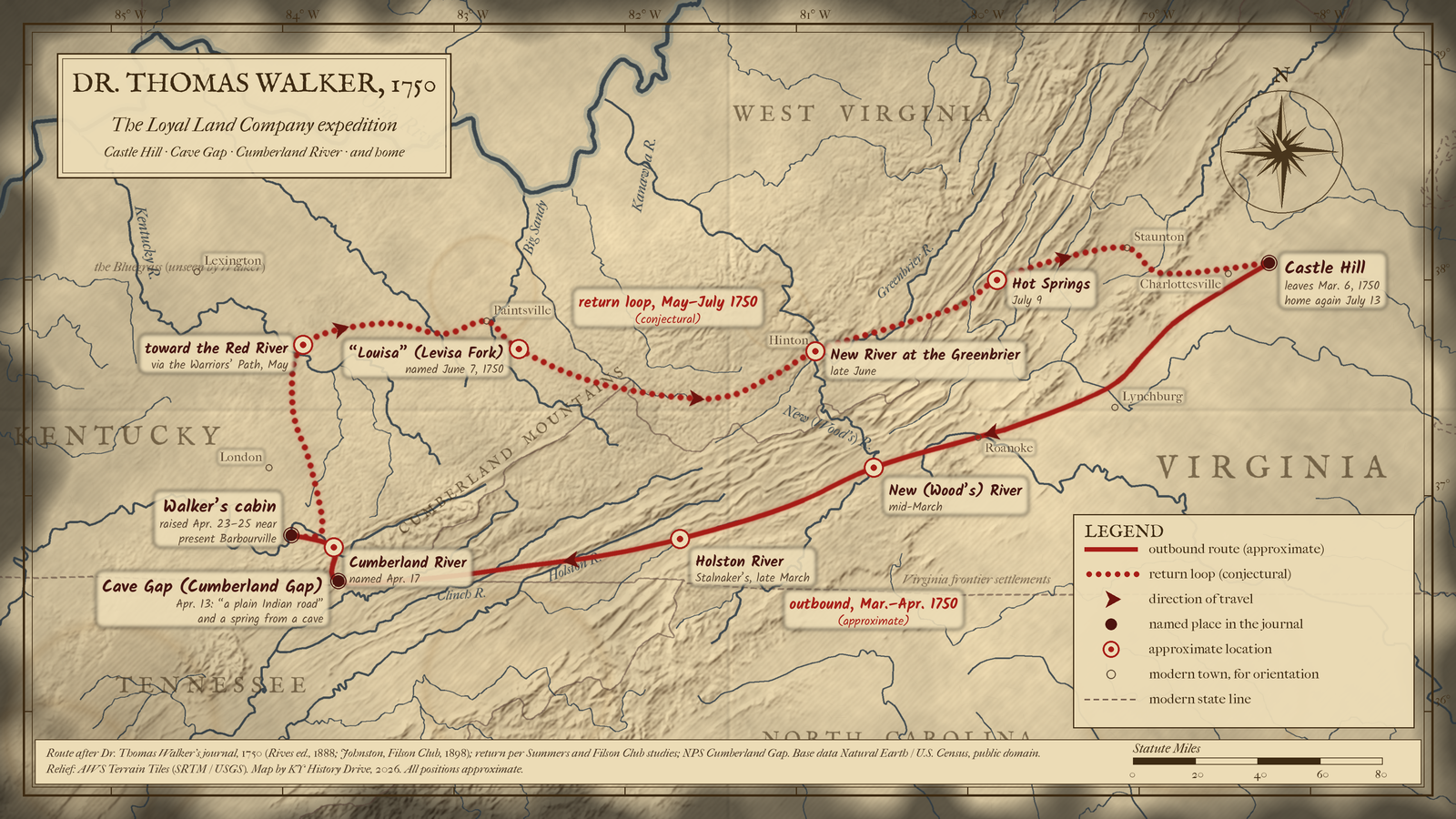
Dr. Thomas Walker left Castle Hill in Albemarle County on March 6, 1750, crossed the Blue Ridge and the New, Holston and Clinch rivers, went through Cave Gap (Cumberland Gap) on April 13, named the Cumberland River, and raised a cabin near present Barbourville. He then looped north on the Warriors' Path toward the Red River, east past Paintsville to the Levisa Fork ("Louisa"), over to the Tug Fork and the New and Greenbrier rivers, and home by Hot Springs and Staunton on July 13.
About 350 miles out to the cabin and 400 back, roughly 750 miles in four months, measured on the map line.
Opens a larger view of this map.
Solid: outbound route (approximate) · Dotted: return loop (conjectural). Map: Kentucky History Drive.
Hexagon: conjectural stop
Kentucky leg shown — view full route
Download GPX (approximate) Download KML (approximate) for GPS and map apps
Approximate stops, in order of travel
- near Cismont / Keswick, Albemarle County, Virginia (Castle Hill)
- Rockfish valley, Albemarle and Nelson counties, Virginia (Col. Fry's, Thomas Joplin's, and John Harvie's)
- Lynchburg to Roanoke corridor, Bedford and Roanoke counties, Virginia (Fluvanna crossing and the Blue Ridge)
- near Radford / Ingles Ferry, Montgomery and Pulaski counties, Virginia (New (Wood's) River)
- Chilhowie area, Wythe and Smyth counties, Virginia (Reed Creek and the Holston at Stalnaker's)
- Clinchport and Powell Valley, Scott and Lee counties, Virginia (Clinch River and Powell Valley)
- Cumberland Gap, Bell County, Kentucky, Lee County, Virginia, and Claiborne County, Tennessee (Cave Gap)
- Pineville, Bell County, Kentucky (Cumberland River (Cumberland Ford))
- near Barbourville, Knox County, Kentucky (cabin at Swan's Pond)
- Flat Lick toward the Irvine area, Knox County to Estill and Powell counties, Kentucky (north on the Warriors' Path, conjectural)
- Hazel Green, Salyersville, and Paintsville, Wolfe, Magoffin, and Johnson counties, Kentucky (old trail to Paint Lick, conjectural)
- Levisa Fork below Paintsville, Johnson and Floyd counties, Kentucky (Louisa (Levisa Fork), conjectural)
- Williamson area toward Mercer and Summers counties, Pike County, Kentucky, and Mingo and Mercer counties, West Virginia (Tug Fork, conjectural)
- Hinton, Summers County, West Virginia (New River near the mouth of the Greenbrier, conjectural)
- Ronceverte toward Allegheny Mountain, Greenbrier County, West Virginia, and Alleghany County, Virginia (up the Greenbrier, conjectural)
- Hot Springs, Bath County, Virginia (Hot Springs, conjectural)
- Staunton, Augusta County, Virginia (Augusta Court House, conjectural)
- Afton to Keswick, Nelson and Albemarle counties, Virginia (over Rockfish Gap to Castle Hill, conjectural)
Sources: Walker's journal (Rives 1888; Johnston 1898).
Cite this story
Published . Last revised .
Chicago
Snowden, Shannon. "Thomas Walker and Cumberland Gap." Kentucky History Drive. Published September 12, 2026. Last revised October 26, 2026. https://kyhistorydrive.com/stories/thomas-walker-and-cumberland-gap/.
MLA
Snowden, Shannon. "Thomas Walker and Cumberland Gap." Kentucky History Drive, published 12 Sept. 2026, last revised 26 Oct. 2026, https://kyhistorydrive.com/stories/thomas-walker-and-cumberland-gap/.
Report a correction for Thomas Walker and Cumberland Gap (opens in a new tab)